
Simon Glairy is a recognized expert at the intersection of insurance and technology, bringing a sharp lens to how carriers navigate the chaotic aftermath of natural disasters. In this conversation, we explore the evolving landscape of catastrophe response, focusing on the shift from manual, property-by-property inspections to intelligence-led operations fueled by high-resolution aerial data. We discuss the critical “72-hour visibility gap,” the logistical pressures on claims teams during landfalls, and why a “quiet” hurricane season can be a deceptive trap for unprepared insurers. By examining how data compresses response times from weeks to days, we uncover a future where directional certainty at scale matters more than the traditional, slower pace of individual property inspections.
The first 72 hours after a catastrophe are often hindered by debris and infrastructure damage, leaving carriers effectively blind. How do claims teams overcome this immediate visibility gap to prevent their operations from being completely overwhelmed?
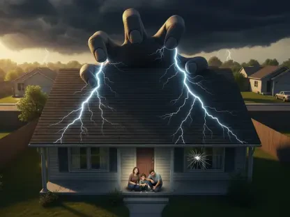
The initial three days after a major hurricane or storm are arguably the most stressful period for any claims organization because they are effectively flying blind while the clock is ticking. You have a landscape where roads are choked with fallen trees, neighborhoods are submerged under feet of standing water, and the very infrastructure needed for communication and travel is often shredded. Traditionally, this created a massive bottleneck where deployment and reserving decisions were based on guesswork or historical patterns rather than the reality on the ground. By using high-resolution aerial imagery, carriers can now bypass these physical obstacles entirely, gaining situational awareness within hours of the storm’s passing. This technology allows them to see the blue tarps, the missing shingles, and the structural failures across an entire portfolio before an adjuster can even clear a path to the front door, turning that 72-hour period from a time of uncertainty into a window of strategic action.
Traditional catastrophe workflows rely on adjusters moving property by property to build a picture of severity. Why is this sequential model failing in the face of modern, large-scale hurricanes, and how does imagery change that approach?
The traditional model is essentially a linear process in a non-linear disaster; it simply doesn’t scale when you have thousands of policyholders affected in a single afternoon across a dense urban region. When an adjuster moves property by property, they are building a very high-detail puzzle one piece at a time, but the carrier needs to see the whole picture immediately to manage their portfolio-level exposure. High-resolution imagery changes the nature of decision-making by prioritizing “directional certainty” over the granularity of a single site visit in the early phase. This means that instead of waiting weeks for a field report to confirm a loss, a carrier can look at an entire impacted geography and see that a specific percentage of their insured properties have severe roof damage. This shift from fragmented inspections to portfolio visibility allows for a more defensive and accurate claims decision process, ensuring that the gating factor for action is no longer the speed of a single person in a car.
Property-level intelligence is often discussed as a tool for efficiency, but how does it specifically improve the triage process and the actual deployment of adjusters into a disaster zone?
It’s about making the entire claims engine run more intelligently by filtering the noise out of the system before the first boots hit the ground. When you combine aerial data with property-level intelligence, you can identify clear indicators of severe damage—such as structural compromise or massive roof failure—and prioritize those claims for immediate, high-touch assistance. This speeds up the identification of severe losses and ensures that your limited pool of field adjusters isn’t being wasted on low-severity claims that could have been handled remotely or through more streamlined workflows. There is an emotional component to this as well; being able to tell a policyholder that you’ve already assessed their damage from the air and have a plan in place provides immense relief during a time of total chaos. Shorter claims cycle times aren’t just a metric; they represent a faster return to normalcy for people whose lives have been turned upside down, all while improving reserving confidence for the carrier.
Many experts worry that remote assessments might eventually replace human judgment in the field. How do you view remote assessment as a filtering mechanism rather than a total replacement for on-the-ground expertise?
Human judgment remains the heartbeat of the claims process, especially when you’re dealing with the emotional weight of a total loss or the nuance of interior water damage. Remote assessment is best understood as a filtering mechanism that determines where that precious human expertise is actually required, rather than a tool to replace the adjuster. It helps us reserve in-person resources for the most complex, high-value, or disputed claims while allowing more straightforward exterior losses to move through a fast-tracked workflow based on standardized imagery. This allows an adjuster to focus on the interior damage or the intricate details of a commercial loss that a camera simply cannot capture from the sky. Most catastrophe inefficiency actually originates in the office during those early assignment decisions, and by providing full visibility, we empower adjusters to spend their time on the ground where they are truly indispensable.
Even when the hurricane season is forecast to be relatively quiet, billion-dollar weather events are becoming more frequent. Why is it vital for carriers to maintain high operational readiness regardless of the storm count?
There is a deceptive comfort in a quiet forecast, but for insurers, the number of storms that form is far less important than the specific location where one of them makes landfall. Data from the National Oceanic and Atmospheric Administration shows us that billion-dollar weather events are carrying an increasing financial impact, even in years that are not extreme in frequency. It only takes one single landfall in a high-exposure, densely populated area to completely overwhelm a carrier’s claims operation and lead to outsized insured losses that dwarf a more active season. This concentration effect means that you cannot afford to relax your operational posture; you have to be ready to see, understand, and act at a moment’s notice because loss volatility is driven by impact, not probability. Catastrophe outcomes are dictated by the reality of landfall, and readiness must be maintained continuously because the potential for a single high-impact event is always lurking behind a quiet forecast.
As carriers look to the future, how can they move away from being reactive and start “operationalizing” aerial intelligence into their existing workflows?
Operationalizing this data is the next frontier, moving the focus from “if” we use aerial intelligence to “how” we weave it into the fabric of daily claims operations. Effective implementation means defining specific severity thresholds for triage decisions and ensuring that imagery is fully integrated into the existing claims management systems. We also need to establish validation workflows between remote and field data, training CAT teams on the logic of when to escalate a claim for a physical inspection. When this is structured effectively, aerial intelligence becomes a seamless operational layer that improves the quality of every decision across the claims lifecycle. It improves the coordination between leadership and field teams during surge events, ensuring that timing and clarity are never compromised even when the volume of claims is at its peak.
What is your forecast for the future of catastrophe response?
My forecast is that the industry will undergo a total structural shift from being “inspection-led” to being “intelligence-led.” We are moving toward a world where response latency—the time it takes to understand the scope of a disaster—is the primary competitive advantage for carriers in the market. In the coming years, we will see insurers compress the timeline between a storm’s landfall and full portfolio-level understanding from several weeks down to just a few days. This won’t just be about faster payouts; it will fundamentally change how CAT organizations allocate their finite resources and manage the massive uncertainty of billion-dollar events. Ultimately, high-resolution imagery and property intelligence will become the standard layer that turns the chaos of a catastrophe into a manageable, data-driven response that better serves the policyholder.