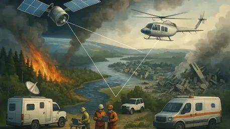

With the continuous occurrence of natural disasters around the globe, technology has emerged as a critical enabler of effective disaster response. Notably, satellite-based disaster management has revolutionized the way stakeholders anticipate, respond to, and mitigate the consequences of catastrophic events. This technology review delves into the sophisticated capabilities of satellite-based systems, evaluating their evolution, characteristics, effectiveness, and practical implementations. The overarching goal is to provide comprehensive insight into the current landscape and future outlook of these advanced technologies in disaster management.
Core Components and Their Functionality
At the heart of satellite-based disaster management lie key principles and essential components meticulously orchestrated to enhance disaster response. This technology integrates advanced satellite systems, including Synthetic Aperture Radar (SAR), which offers unparalleled data acquisition capabilities. Operating independently of weather and light conditions, SAR satellites deliver critical real-time information essential for effective decision-making during crises. By offering comprehensive imagery and data analytics, these satellites play a pivotal role in modern disaster management initiatives.
The significance of satellite-based technology is underscored by its seamless integration into the broader landscape of disaster response and technology. These systems empower humanitarian organizations, governments, and international bodies with vital intelligence that facilitates informed decision-making. Moreover, within the ever-evolving spectrum of technological advancements, satellite-based disaster management continues to stand out as a crucial innovation, bringing effectiveness and precision to disaster response strategies worldwide.
Features and Capabilities of Satellite Technology
The Role of Synthetic Aperture Radar (SAR) Satellites
Synthetic Aperture Radar technology constitutes a fundamental pillar of modern satellite-based disaster management. With its unique ability to penetrate clouds and darkness, SAR technology is crucial for acquiring accurate data in near real-time. This functionality proves indispensable during severe weather conditions when visual clarity is often compromised. SAR’s precise imaging capabilities enable rapid damage assessments, offering timely assistance in crucial decision-making.
Integrated Solutions for Disaster Management
An example of an integrated disaster management solution is ICEYE’s Hurricane Solution, which exemplifies the fusion of SAR satellites with data analytics. This holistic approach ensures swift damage assessment and situational awareness in the immediate aftermath of natural disasters. By providing data within hours, integrated systems like these empower stakeholders with actionable intelligence, thereby enhancing response efficiency and ultimately minimizing loss and damage.
Recent Advancements and Emerging Trends
Satellite-based disaster management continues to evolve, thanks to advancements in imaging accuracy and technological sophistication. Recent developments in satellite imaging have significantly improved the precision and clarity of collected data, enhancing the accuracy of disaster assessments. Additionally, emerging trends such as real-time data integration and enhanced predictive analytics are propelling satellite-based solutions toward new frontiers. These innovations are set to redefine disaster management, offering deeper insights and more effective preventative measures.
The continuous enhancement of satellite technology suggests a trend toward the automation of data processing and the increased use of artificial intelligence. These innovations allow for faster data analysis, enhancing the speed and efficiency with which information is processed and disseminated. As a result, stakeholders equipped with improved technological tools are better positioned to tackle disaster-related challenges proactively.
Practical Applications and Notable Use Cases
Satellite-based disaster management has seen widespread applicability across various sectors, each benefiting from its advanced capabilities. In the insurance industry, the integration of satellite data allows for precise risk assessment and prompt claims processing. This translates into a more responsive approach to catastrophe insurance, where stakeholders can make informed decisions based on real-time data. The synthesis of data into actionable insights empowers insurance companies to mitigate financial risks more effectively.
MAPFRE RE stands as a notable example of how real-world applications of satellite data are taking shape. This global reinsurer, in collaboration with ICEYE, utilizes flood insights from satellite data within its catastrophe response framework. By integrating flood data swiftly, MAPFRE RE can quickly assess financial impacts and maintain situational awareness, particularly in traditionally underserved regions. Such collaborations underscore the tremendous potential of leveraging satellite technology to strengthen disaster preparedness and resilience.
Addressing Challenges and Overcoming Limitations
Despite its myriad benefits, satellite-based disaster management encounters several challenges that must be navigated. Technical challenges involve ensuring data accuracy, interoperability, and the frequent refresh of satellite information. Addressing these challenges calls for continuous improvement in satellite imaging processes, data storage solutions, and robust analytical algorithms to maximize operational efficiency and effectiveness.
Apart from technical obstacles, regulatory and market barriers hinder the widespread adoption of satellite-based disaster technology. Navigating these complex regulatory environments requires collaboration with governmental bodies and stakeholders to align on standards and protocols. Additionally, broader market acceptance necessitates increased awareness and education about the substantial advantages of this technology in disaster management strategies.
Outlook and Potential Impact
The future of satellite-based disaster management appears promising, driven by ongoing advancements and innovative applications. As satellite technology continues to evolve, potential breakthroughs include the enhancement of predictive analytics, offering improved forecasts of disaster occurrences and impacts. Further integration with emerging technologies such as blockchain could enhance transparency in disaster response efforts.
In the long term, the expansive impact of satellite-based technology on disaster management and related industries is expected to grow exponentially. The adoption of these solutions signifies a step toward greater resilience and preparedness, with the potential to transform conventional approaches to disaster risk mitigation. As organizations increasingly prioritize proactive disaster management strategies, satellite technology will likely remain at the forefront of enhancing strategic outcomes.
Key Takeaways
The review of satellite-based disaster management technology highlights its significant contributions to modern disaster response strategies. At present, the technology offers advanced capabilities through components like SAR satellites and integrated disaster solutions. It has demonstrated its effectiveness through diverse practical applications, such as those implemented by MAPFRE RE, showcasing the transformative power of satellite data.
However, addressing challenges remains crucial to unlocking the full potential of this technology. Continuous innovation and collaboration are key to surmounting technical and regulatory obstacles, ensuring that satellite-based disaster management evolves to meet emerging needs. The trajectory of this technology demonstrates a positive and impactful vision for the future, with the promise of revolutionizing disaster management practices worldwide.