
Simon Glairy has spent years at the nexus of insurance, Insurtech, and maritime risk, building AI-driven tools that triage shipboard incidents and price volatile routes in real time. Today he unpacks twin tanker fires in the Black Sea that rattled underwriters and operators alike: how mine hazards, shadow-fleet practices, and murky flag status collide with casualty response, salvage, and war-risk cover. We talk through incident timing and offshore distance, ballast conditions and engine-room fires, ad hoc SAR integration, mine attribution and routing choices, compliance and exclusions, as well as the stubborn operational gaps in clearance efforts by Turkey, Bulgaria, and Romania. He also translates uncertainty into underwriting language—rating models, wordings, deductibles—and closes with the three metrics that best surface shadow-fleet exposure before it becomes tomorrow’s headline.
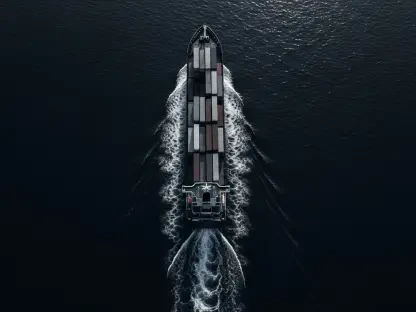
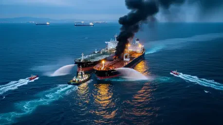
Two sanctioned tankers, Kairos and Virat, reported “external impact” north of Turkey the same day. How do you interpret the timing and distance (28 nm and 35 nm offshore), and what patterns do you see? Walk me through comparable cases, metrics, and your step-by-step incident triage.
When two tankers with similar profiles report “external impact” roughly 28 nautical miles and 35 nautical miles off the same coastline on the same day, I look first for common environmental and operational denominators: sea state, mine drift patterns, traffic density, and whether both ships were on comparable routes toward or across approaches tied to Novorossiysk and the broader Black Sea lanes. That proximity offshore is meaningful—it places them well outside immediate coastal safety buffers but within zones where drifting ordnance has repeatedly been identified since the war began. The pattern that repeats in comparable cases is an abrupt machinery-space alarm followed by a fire signature that either escalates quickly or is contained by early-space suppression; that split tells you a lot about whether the initiating energy came from within the engine room versus a shock from the hull side. My triage runs in four steps: stabilize people (headcount, muster, PPE), stabilize the vessel (fire boundaries, watertight integrity), stabilize the scene (exclusion radius, traffic advisories), and stabilize the narrative (initial cause hypotheses logged separately from public statements), while tagging metrics like time to first distress call, distance to shore assets, and whether there were previous AIS anomalies on the voyage.
Kairos was in ballast and reportedly had an engine-room blast. How does being in ballast change fire behavior and casualty risk versus laden voyages? Share a blow-by-blow of heat spread, suppression tactics, and any metrics on ignition sources you’ve seen in similar events.
Ballast is the lesser of two evils because you’ve removed a massive fuel load—cargo oil and its vapor space. In an engine-room event, heat initially rides up draft flows along trunking and cable runs; in ballast, you worry less about radiant heat flashing vapors in adjacent cargo spaces and more about power failure cascading into loss of pumps for boundary cooling. The blow-by-blow is familiar: local detection, then automatic or manual activation of fixed systems while teams pull portable extinguishers and set cooling lines on bulkheads. Ventilation is the pivot—closing dampers to starve oxygen without baking adjacent compartments. Ignition sources in these cases tend to cluster around hot surfaces in machinery spaces and fuel atomization, so we document the first alarm time stamp, which breakers tripped, and whether the crew secured ventilation quickly—those are the telltales that decide whether fire remains a contained machinery-space casualty or migrates topside.
Turkish authorities deployed rescue boats, a tug, and an emergency response vessel, with all crew saved. What made that response effective at sea state and distance? Describe the timeline, on-scene coordination playbook, and key response metrics you track during such operations.
At 28 nautical miles and 35 nautical miles, you’re in the sweet spot where coastal authorities can project assets quickly yet still coordinate with merchant shipping on-scene. What made it work was layered capability: rescue boats for fast personnel transfer, a tug for firefighting and potential tow, and a dedicated emergency response vessel for command-and-control. The playbook is simple but disciplined: confirm distress, assign on-scene coordinator, establish a safety sector upwind, and prioritize evacuation versus firefighting based on heat and smoke conditions. I track time from distress to first asset on-scene, number of people transferred per evolution, and whether the tug’s monitors established effective boundaries without forcing flame rollover—those are the metrics that foreshadow whether you’ll pivot to salvage or prepare to abandon and mark wreck.
Virat reported heavy smoke in the engine room and nearby commercial shipping assisted. How do you integrate ad hoc support from merchant ships into formal SAR? Give an example of comms protocols, checklists, and handoff steps that prevent confusion or duplicate efforts.
The key is to deputize without devolving into a free-for-all. We slot the first merchant ship as an interim on-scene coordinator until the state asset arrives, with a simple checklist: report position, wind, sea, visible flame or smoke, headcount, and immediate hazards. Comms move to a primary working channel with a backup, and the assisting ship holds station upwind to act as a refuge and visual reference. Handoff is explicit: when the designated authority arrives, the merchant ship provides a brief, transfers any evacuees, and either departs or stays as a standby platform. That sequence avoids overlap in firefighting water application, which can be dangerous if multiple streams are driving heat and smoke unpredictably around a hull.
Tribeca suggested Kairos may have struck a mine and risked sinking. How do you validate mine-strike versus internal failure in real time? Walk me through your evidence ladder, from sensor data to hull forensics, and share probability ranges you assign at each stage.
Real-time, we separate engine-room initiated events from hull-origin shocks by listening to the sequence: did alarms start in machinery spaces before the crew felt a jolt, or was there a sudden shock followed by multiple alarms lighting up at once? On the evidence ladder, we start with crew testimony and sensor chronology, then look for external deformation patterns on the shell, scorch and spall directionality, and whether flooding appears in a compartment inconsistent with machinery-space origin. We also weigh local mine warnings and the proximity to known drift corridors. Early on, I use qualitative bands—possible, plausible, likely—because the penalty for false precision is high; only after hull forensics and compartment inspections do we elevate confidence.
More than 100 naval mines have been found in the Black Sea since the war began. How does this mine density translate into routing decisions and day-rate risk pricing? Give a concrete route example, the clearance intel you use, and the risk premium math.
That figure has a psychological and operational weight: it forces us to segment routes by mine encounter likelihood and the resilience of local clearance protocols. A run into or past approaches tied to Novorossiysk or near Ukrainian ports is judged against current notices of drifting ordnance and recent interdictions by Turkey, Bulgaria, and Romania. The pricing response is to treat day-rate as a base plus a war-risk variable keyed to route segments and current advisories; recent clearance reports downgrade that variable, new sightings raise it. The intel comes from maritime authorities’ notices and operators’ near-miss logs; when those show recent finds along a planned leg, we recommend a wider berth and adjust the risk charge accordingly.
A Panama-flagged ship hit a mine in late 2023, and an Estonian vessel sank near Odesa in 2022. What lessons from those cases apply here? Compare hull damage patterns, drift models, and the most useful changes to watchkeeping or speed profiles.
Those cases taught us that damage from drifting mines can present as localized but catastrophic breaches with quick compartment flooding and that the direction of plating deformation helps discriminate external blast from internal faults. Drift models reminded us that mines don’t respect charted deployment lines; they ride currents and weather and can appear far from origin points. The most useful operational changes were heightened lookout discipline and a speed profile that balances maneuverability with the ability to avoid creating dangerous pressure gradients near suspected objects. In practice, that means eyes outside as much as eyes on the panel, and a deliberate approach to course alterations in areas flagged by recent finds.
Analysts link most mine-laying to Russian forces, with drift near Crimea and Ukrainian ports. How do you factor political attribution into underwriting and compliance? Share how you adjust exclusions, war-risk triggers, and claims reserves when attribution is contested.
Attribution matters for sanctions, war-risk triggers, and whether certain exclusions bite, but we treat it as a variable with a moving confidence band. If attribution points strongly to state-related activity near Crimea or approaches to Ukrainian ports, we tighten wordings around acts of war and require clearer voyage disclosures. When it’s contested, we build reserves as if the loss could fall under either war perils or machinery damage and keep both lanes open until verified. Compliance teams also cross-check ownership structures to ensure that any implied trade links don’t breach sanction screens, especially where shadow-fleet practices blur the picture.
Kairos was reportedly removed from the Gambian registry for fraudulent certificates, leaving it stateless and likely uninsured. How does flag uncertainty change casualty handling and salvage priorities? Walk me through the legal, P&I, and port-state steps you’ve navigated in such cases.
Flag uncertainty complicates everything. Without a valid flag, you risk having no recognized insurer or class to lean on, which shifts the burden to coastal states to mitigate hazards first and sort liability later. Practically, we secure the scene, request proof of cover, and, if none is forthcoming, coordinate with port-state control to authorize immediate measures to protect life and the marine environment. Salvage priorities skew toward pollution prevention and traffic safety; only once stability is assured do we entertain complex tows or hot work, and the legal paperwork runs in parallel to avoid paralysis.
Shadow-fleet tankers often hide ownership and lack verifiable class and insurance. What specific red flags—AIS gaps, odd survey stamps, routing quirks—most reliably predict trouble? Share a real case, the indicators you logged, and how you escalated before an incident happened.
The trifecta of risk is prolonged AIS silence around sensitive waypoints, survey notations that don’t trace back to a recognized registry, and routing behavior that hugs coasts to stay just outside typical inspection zones. In one case, the vessel cycled flags quickly and displayed certificate references that didn’t match the supposed flag’s format, while its voyage legs consistently skirted areas known for mine clearance in progress—behavior designed to avoid scrutiny. We logged the gaps, cross-referenced certificates, and escalated to require independent condition verification before binding cover; when that wasn’t forthcoming, we declined, which is often the hardest but safest call.
Bosphorus traffic continued despite visible smoke. How do regulators balance flow versus hazard in a chokepoint? Give an example of threshold metrics—visibility, wind, exclusion zones—and the decision tree for closing, restricting, or convoying traffic.
In a chokepoint, shutting down traffic is never taken lightly, so regulators lean on threshold metrics and dynamic zoning. If smoke plumes reduce visibility below safe minima or wind threatens to push fumes across shipping lanes, authorities carve out an exclusion bubble and may stagger passage. The decision tree runs from monitor-only to restricted transits to full closure, with convoying as a middle ground to concentrate control and escort capability. In this case, visible smoke didn’t halt the Bosphorus, suggesting thresholds weren’t crossed and that responders maintained a safe perimeter away from the main artery.
With mine-clearing by Turkey, Bulgaria, and Romania ongoing, what operational gaps still worry you? Describe the most effective clearance method you’ve seen, its limits in rough seas, and the cadence of re-surveys needed to keep risk tolerable.
The gap is persistence: mines that break free, move, and re-seed areas thought to be clean. The most effective method combines detection, neutralization, and immediate re-survey of adjacent lanes, but rough seas blunt sensor performance and complicate disposal. The cadence we push for is frequent re-checks after bad weather and after any reported sighting; treating clearance as an event rather than a process is where we get blindsided. We also need better integration between national programs so that a cleared segment in one zone doesn’t lull operators into complacency just over the line.
For underwriters, uncertainty is widening in the Black Sea. How are you updating rating models, wordings, and deductibles this quarter? Share the data sources you lean on, the variables you’ve reweighted, and a before-and-after premium example for an aframax transit.
We’ve reweighted route segment risk, shadow-fleet indicators, and SAR response proximity, and we’ve tightened wordings around war perils and compliance disclosures. Data flows from official maritime notices, mine discovery reports, and operator incident logs, plus our own anomaly tracking on AIS behavior. Deductibles are being aligned with machinery-space versus external-impact pathways so we don’t conflate very different loss types. For an aframax leg across these waters, the qualitative shift is clear: higher variable war-risk component where recent mine activity is reported, with conditions precedent tied to route transparency and watchkeeping standards.
Looking ahead to salvage, what factors decide whether Kairos or Virat are recoverable? Walk me through stability checks, gas-freeing, hot work permits, and towage planning, and give a timeline and cost band based on recent Black Sea salvage jobs.
Recoverability starts with stability: compartment status, residual heat, and whether you can safely move power around the ship. Gas-freeing is non-negotiable before any hot work; even in ballast, fuel residues in machinery spaces demand careful testing and ventilation. Towage planning then hinges on hull integrity, steering capability, and the nearest safe haven with capacity to receive and manage a casualty. Timelines and costs swing with weather and damage scope, so we bracket them as multi-phase: stabilization, transfer, and repair assessment, each with its own risk gates rather than a single date on a calendar.
If you had to brief a board today, what three metrics would you highlight to track shadow-fleet exposure? Explain how you’d collect them weekly, the thresholds that trigger action, and one anecdote where early warning changed an operational decision.
I’d highlight AIS anomaly rate along high-risk legs, certificate provenance anomalies, and proximity to recent mine sightings. Weekly, we automate pulls from movement data, parse certificate references against known formats, and layer notices of drifting ordnance onto route plans. Action triggers when anomaly rates spike, when documents don’t resolve to a recognized authority, or when planned legs intersect fresh mine reports; the response is to re-route, add conditions, or decline cover. We once paused a voyage when the anomaly rate and document inconsistencies climbed together; a week later, the area saw renewed mine activity, validating the early stop.
Do you have any advice for our readers?
Treat uncertainty as a managed input, not a surprise. Build disciplined checklists for machinery-space readiness, route transparency, and SAR integration, and keep your communications crisp when things go sideways. For underwriters and operators alike, the watchwords are verification and vigilance: verify documents and routes, and maintain vigilance in zones where more than 100 mines have already been found. The Black Sea remains workable, but only for teams that assume conditions can change between breakfast and lunch—and plan accordingly.