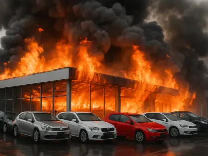

In an era marked by the increasing incidence of wildfires, hurricanes, and other climate-related disasters, technology is stepping up in remarkable ways to protect personal assets and community infrastructure. Lidar, a cutting-edge technology originally developed for atmospheric studies and space exploration, is now accessible to individuals through smartphone applications. This digital innovation allows homeowners to create detailed 3D representations of their properties, serving as critical documentation in the wake of climate catastrophes. The narrative of tech entrepreneur Chris Heinrich, whose digital preservation of his home provided a lifeline amidst the ruins left by Los Angeles County wildfires, underscores lidar’s transformative power in emergency scenarios.
The Emergence of Lidar Technology As a Key Tool
From Scientific Instrument to Everyday Guardian
Originally developed in the 1960s, lidar scanning technology found its origins in research applications focused on weather prediction and lunar mapping. This sophisticated tool was primarily bound to significant scientific endeavors, often inaccessible to the general public due to prohibitive costs and complexity. In recent years, advances have democratized this once-niche technology, making it available through applications like Polycam, Matterport, and Docusketch. Today, modern smartphones—embedded with tiny lasers initially intended for camera autofocus—can effectively function as lidar scanners, enabling individuals to document real estate in precise 3D detail. This breakthrough in accessibility underscores the creative adaptation of existing technology to meet urgent contemporary needs.
The Impact on Insurance Claims and Property Documentation
Lidar’s newfound application in documenting real estate has created a revolution in property preservation, particularly urgent given the increased unpredictability of climate phenomena. Homeowners are now empowered to generate comprehensive visual documentation of their assets, providing indisputable evidence of pre-disaster conditions—a critical factor in ensuring speedy and effective insurance claims. Stephanie Lin of Matterport illuminates how technology originally intended for virtual property tours now serves communities besieged by weather extremes, transforming into a forensic aid that captures the intricate details often missed by traditional methods. As destructive events become more frequent, clear documentation extends beyond personal necessity, serving as a vital tool for preserving significant historical sites.
The Strategic Advantages of Digital Archiving
Building a Resilient Recovery Framework
In settings vulnerable to climate adversities, establishing a robust digital archive becomes essential for swift recovery efforts post-disaster. A pivotal example transpired in Brick Township, where digital archiving proved invaluable after Hurricane Sandy wreaked havoc. The township’s investment in digitizing records secured critical recovery funds by providing digital copies of essential documents traditionally at risk. This foresight underscores the role of modern technology in fortifying responses amid the increasing frequency of natural disasters. The emerging importance of virtual records and 3D documentation is highlighted by their ability to rapidly authenticate property status, proving to be indispensable tools in efficient recovery and rebuilding processes.
Navigating Challenges with Insurance Coverage
While lidar scanning presents significant advantages for property owners, it simultaneously highlights emerging challenges that insurers face due to escalating risks in regions prone to disasters. As wildfires become increasingly severe and frequent, insurance companies strain under the pressure of repeated claims, necessitating precise documentation like lidar scanning to alleviate system burden. Yet, for homeowners residing within high-risk zones, securing reliable insurance coverage becomes daunting as companies reevaluate underwriting policies amidst heightened environmental dangers. This trend poses a concern, emphasizing the need for innovative approaches to balance technological efficiency and insurance landscape complexities, seeking to ensure continuity in coverage.
Real-Life Experiences with Lidar Scanning
Streamlining Insurance and Reconstruction Processes
Real-life narratives from individuals like Chris Heinrich and Ethan Goldspier illustrate lidar technology’s vital role in facilitating insurance claims and reconstruction. Goldspier faced the demands of proving the loss of possessions to his insurance company following the Los Angeles fires, a task significantly eased by his comprehensive digital scan of his home. Capturing intricate details of furniture, appliances, and art, the 3D representation provided a streamlined solution for documenting losses—a formerly daunting process now rendered efficient. As destructive events intensify, this technology proves increasingly valuable, evidenced by Goldspier’s accelerated claim process and plans to reconstruct using his digital blueprint. These insights affirm lidar’s tangible benefits in managing the complexities of disaster aftermath.
Professional Adaptation to New Technologies
In professional spheres, lidar technology fosters unprecedented efficiencies in property appraisal and documentation, reshaping conventional methodologies. David Ma’s involvement with Rainbow Restoration exemplifies this transformation, transitioning from exhaustive manual audits to expedited phone-based scans for assessing post-damage scenarios. Utilizing lidar technology, tasks initially demanding substantial time investment are compressed into brief and precise operations, fulfilling a critical need for rapid yet thorough documentation in disaster responses. This efficiency empowers individuals and communities seeking timely insurance assessments and expeditious recovery, delineating a future where swift appraisals support resilience against climate adversities.
Beyond Immediate Applications: Preservation of Heritage
Protecting Cultural and Historical Sites
Expanding the scope beyond immediate property protection, lidar technology plays a crucial role in safeguarding cultural heritage sites vulnerable to climate impacts. Researchers employ this tool for preserving archaeological sites and at-risk structures, leveraging 3D scans to capture intricate details for future conservation or reproduction. Matterport’s contributions to documenting the internal spaces of Egyptian pyramids illuminate lidar’s potential in preserving age-old wonders, while Andrew Law’s exploration of historical sites in China threatened by damming projects further exemplifies this utility. Lidar scanning emerges as a vital instrument, enabling scholars to maintain digital records of endangered sites, ensuring continuity in understanding cultural legacies amid environmental threats.
Pragmatic Concerns and Technological Limitations
Despite lidar technology’s promising advantages, limitations persist that practitioners must navigate to ensure effective application. Achieving comprehensive scans necessitates unwavering concentration to guarantee precision and completeness, as inaccuracies may impede the recovery process or complicate insurance claims. Moreover, digital replicas cannot rectify sites environmentally degraded beyond rebuilding, presenting a pragmatic challenge influencing future reconstruction efforts. The potential recurrence of disasters heightens the difficulty of insurers maintaining coverage in risky locales, spotlighting the precarious reality of residing in environmentally volatile regions. These concerns necessitate a delicate balance between futuristic aspirations and pragmatic considerations influencing property safeguarding strategies.
Balancing Costs and Accessibility
Economic Considerations in Deploying Lidar
While recent developments have reduced the cost barriers associated with lidar technology, economic considerations remain relevant for homeowners aiming to employ these tools for asset protection. Matterport’s entry-level kits offer accessible solutions priced at $149, yet high-end equipment can reach substantial figures of $9,000. The free Polycam app provides versatility but may lack the detail attained through specialized cameras—a critical factor for individuals addressing immediate post-disaster documentations. These expenses represent important considerations for users evaluating the technology’s practical benefits relative to its financial implications, emphasizing the ongoing dialogue surrounding balancing affordability with effectiveness in disaster preparedness strategies.
Emotional Impacts of Digital Preservation
Beyond its functional utility, digital reconstructions facilitated by lidar technology carry profound emotional significance for individuals grappling with loss. Heinrich’s reflections on the digital replica of his obliterated home liken the experience to witnessing a demise—the physical structure exists only virtually, highlighting the irreplaceability of lived experiences. For Goldspier and Heinrich alike, these scans symbolize not only spatial assets but also cherished memories accumulated over time. This emotional burden makes evident the complex interplay between technology-driven resolutions and the enduring impact of personal loss, inviting contemplation on the human dimension intertwined with pragmatic adaptations to climate challenges.
Weathering the Storm with Technological Innovation
In regions susceptible to climate-related challenges, creating a comprehensive digital archive becomes crucial for efficient post-disaster recovery efforts. A significant case unfolded in Brick Township, illustrating the substantial benefits of digital archiving following the destructive impact of Hurricane Sandy. By prioritizing the digitization of vital records, the township guaranteed access to crucial recovery funds, relying on digital versions of documents traditionally vulnerable in disasters. This proactive approach highlights the integral role modern technology plays in bolstering responses as natural disasters become more frequent. The evolving significance of virtual records and 3D documentation is evident in their capacity to swiftly verify property status, proving essential for effective rebuilding and recovery efforts. As technology advances, communities are better equipped to confront and recover from the aftermath of natural calamities, emphasizing the necessity for continued innovation in disaster preparedness and recovery strategies.