
Setting the Stage for a Data-Driven Insurance Era
In an industry tasked with safeguarding millions of unique properties across the United States, property insurance faces a staggering challenge: accurately assessing risk for roughly 85 million single-family homes, each with distinct features and vulnerabilities that make uniform evaluation nearly impossible. This complexity has long hindered insurers’ ability to price policies fairly and respond swiftly to claims. Enter aerial imagery and geospatial data—technologies that are revolutionizing how the sector operates by replacing outdated, manual processes with scalable, precise solutions. This market analysis delves into the profound shifts driven by these innovations, examining current trends, dissecting data-backed impacts, and projecting future developments. The purpose is to illuminate how technology is reshaping risk assessment, operational efficiency, and customer engagement, offering stakeholders a roadmap to navigate an evolving landscape.
Unpacking Market Dynamics and Technological Impacts
Historical Barriers and the Push for Innovation
Property insurance has historically struggled with data collection due to the sheer diversity of homes, unlike sectors like auto insurance where standardized metrics simplify evaluations. Traditional methods relied on customer input, agent reports, and costly physical inspections, creating inefficiencies that scaled poorly across a vast market. These approaches often led to delays in underwriting and inconsistent risk profiling, impacting pricing accuracy. The advent of aerial imagery, captured via manned aircraft for national mapping, marks a pivotal shift, providing detailed visuals of a significant portion of U.S. properties. This technology addresses long-standing pain points by reducing the need for on-site visits, cutting costs, and enabling faster decision-making, setting a new standard for the industry.
Precision in Risk Assessment Through Visual Data
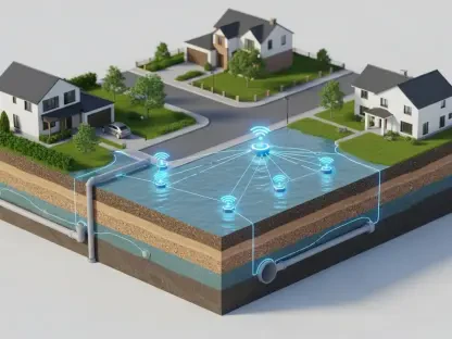
Aerial imagery stands as a cornerstone of current market transformation, offering insurers unprecedented access to external property details without invasive inspections. This capability allows for the evaluation of critical factors such as roof conditions, surrounding hazards, and yard layouts, directly enhancing the accuracy of risk models. Market data indicates that insurers leveraging these tools can reduce assessment errors, leading to fairer policy pricing and tailored coverage options. However, limitations persist—interior conditions remain beyond the scope of imagery, necessitating a blend of traditional and modern methods. Despite this, the trend toward visual data integration signals a broader move to data-driven precision, reshaping how risk is quantified across the sector.
Operational Efficiency Gains in Underwriting and Claims
The integration of geospatial data alongside aerial imagery is driving significant efficiency gains in underwriting and claims processing, a key trend in today’s market. Geocoding technology pinpoints property locations, calculating proximity to risks like flood zones or wildfire areas, which accelerates eligibility decisions. Digitized public records further enrich risk profiles by providing insights into construction types and loss histories, minimizing manual data entry for agents. In claims handling, proprietary platforms identify disaster-affected zones proactively, enabling rapid adjuster deployment during crises like hurricanes. While risks of data over-reliance exist, the market is witnessing a clear shift toward streamlined workflows, with insurers reporting faster quote turnaround times and improved response capabilities.
Proactive Risk Mitigation as a Competitive Edge
Another emerging trend is the use of aerial imagery to foster proactive risk mitigation, positioning insurers as partners in loss prevention. By combining visual data with extensive claims databases, companies can identify vulnerabilities—such as overgrown vegetation near homes in fire-prone regions—and offer actionable advice to policyholders. This approach varies regionally, with coastal areas focusing on flood defenses and western states prioritizing wildfire safeguards. Market analysis suggests that this collaborative strategy not only reduces losses but also strengthens customer trust, creating a competitive advantage. Adoption challenges, such as technology literacy gaps, remain, yet the trend underscores a pivot toward prevention over reaction in the insurance space.
Future Projections and Market Evolution
Integration with Emerging Technologies
Looking ahead, the property insurance market is poised for deeper transformation as aerial imagery integrates with cutting-edge tools like artificial intelligence and machine learning. These technologies could analyze visual data for granular insights, such as detecting wear on building materials or predicting structural risks, enhancing risk models further. Projections suggest that from 2025 to 2027, adoption of AI-driven analytics may grow significantly, driven by rising property values and the need for highly accurate assessments. Regulatory changes around data privacy could influence how imagery is utilized, while drone technology might complement manned aircraft for fresher visuals, though cost and airspace constraints pose barriers. The market is clearly trending toward a tech-centric future.
Economic and Consumer Drivers Shaping Demand
Economic factors, including increasing property values and heightened consumer expectations for personalized service, are expected to fuel demand for advanced assessment tools. Insurers may face pressure to deliver real-time data insights, pushing investments in geospatial platforms and automated systems. Consumer awareness of risk mitigation benefits could also drive uptake, as homeowners seek insurers offering data-backed guidance. Market forecasts indicate a growing segment of tech-savvy customers prioritizing efficiency and transparency, compelling insurers to innovate continuously. This dynamic suggests a feedback loop where technology adoption and market demand reinforce each other, accelerating industry evolution over the next few years.
Shift Toward Preventive Insurance Models
A long-term projection points to a fundamental redefinition of insurance as a preventive rather than reactive service. Aerial imagery and geospatial data lay the groundwork for anticipating risks before they materialize, potentially reducing claim frequencies and severities. Insurers might increasingly position themselves as risk management advisors, leveraging technology to offer predictive insights tailored to regional and individual needs. This shift could reshape market competition, with companies that excel in preventive strategies gaining market share. While challenges like balancing automation with human judgment persist, the trajectory toward prevention promises to redefine value propositions across the sector.
Reflecting on Insights and Strategic Pathways
Looking back, the analysis of aerial imagery and geospatial data’s impact on property insurance reveals a market transformed by technology, with enhanced accuracy, efficiency, and proactive engagement becoming hallmarks of the industry. The findings underscore how these tools address historical inefficiencies, streamline operations, and position prevention as a core focus. For stakeholders, the path forward involves strategic investments in robust data platforms and training to ensure effective technology integration. Insurers are encouraged to prioritize transparency in data usage to maintain customer trust, while agents can shift focus to advisory roles by leveraging automated workflows. Homeowners stand to gain by actively partnering with insurers on risk mitigation, using provided insights to protect their assets. Ultimately, navigating this digital era requires a balanced approach—embracing innovation while preserving the human element to deliver lasting value in a rapidly changing market.